

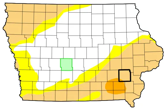
Parts of southeastern Iowa remain in moderate to severe drought, with both short-term and long-term conditions contributing to deficits.
According to Iowa State Climatologist Justin Glisan, February 2026 was warm and dry in Iowa, with temperatures about 8.1 degrees above average. In 154 years of record keeping, that makes it the 13th warmest February on record. February 2026 was also the 10th driest on record, with the state about nine-tenths of an inch below average.
Things were a bit more extreme locally. Glisan says for southeastern Iowa, February 2026 was the driest in 154 years, with warm temperatures making it the 17th warmest on record.
Glisan says March has brought a small rebound in precipitation, but longer term deficits continue to be a problem, “We still have many stations in southeastern Iowa that have, over the last five years, missed out on at least a year’s worth of precipitation. And this is where we see D1 and D2 conditions in southeastern Iowa, moderate to severe drought, on that D0 to D4 scale. So even if we’ve seen a wetter stretch of time through the first 19 days of March, the outlooks through the end of the month are suggesting warmer and drier conditions.”
Drought conditions are tracked through a D0 to D4 scale, with D0 representing abnormally dry conditions and D4 representing exceptional drought.
Glisan says these short-term and long-term deficits, in concert, means that his office will need to remain cognizant of conditions heading into 2026’s growing season. The latest United States drought monitor map, released March 26th, shows continued moderate drought conditions in all of southeastern Iowa, with severe drought conditions in parts of Washington, Keokuk, Jefferson, Henry, Van Buren, and Wapello counties.